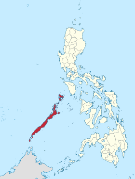
Palawan
probinsya ed Pilipinas
Page Module:Infobox/styles.css has no content.
| Palawan | |||
|---|---|---|---|
| Luyag na Filipinas | |||
 | |||
| |||
 Lokasyon na Palawan | |||
 | |||
| 10°0′0″N 118°49′48″E | |||
| Dalin | Filipinas | ||
| Angipaletnegan | 1818 | ||
| Kabesera | Puerto Princesa | ||
| Barangay | 433 | ||
| Gobiyerno | |||
| • Pangulo | Jose Alvarez | ||
| Kaawang | |||
| • Katiponan | 14,649.73 km2 (5,656.29 sq mi) | ||
| Bilang na too (Mayo 1, 2020)[1] | |||
| • Katiponan | 939,594 | ||
| • Densidad | 64/km2 (170/sq mi) | ||
| Economia | |||
| • Clase | unaan ya klase a luyag | ||
| • Ingresos | ₱3,612,771,740.531,460,733,975.001,536,425,512.001,709,512,652.002,061,026,077.002,288,613,866.002,528,673,734.003,030,844,729.003,109,535,413.993,817,931,110.515,052,353,383.54 (2020) | ||
| • Activos | ₱15,737,202,153.743,409,489,760.003,677,447,183.004,651,138,194.006,595,985,266.008,205,942,589.0010,158,609,226.0011,277,134,448.0013,036,142,132.2816,108,656,950.2018,135,824,113.56 (2020) | ||
| • Pasivos | ₱5,931,247,050.401,174,947,593.001,207,875,109.001,866,820,377.002,942,607,031.00383,094,602.004,936,151,720.005,155,501,628.005,865,541,747.386,547,672,062.396,816,106,126.84 (2020) | ||
| • Gastos | ₱2,544,116,603.131,094,974,251.001,315,462,971.001,331,920,974.001,499,294,496.001,693,983,283.001,985,348,051.002,293,737,909.002,479,831,099.283,101,717,832.983,432,813,259.30 (2020) | ||
| Kodigo na postal | 5300–5322 | ||
| Kodigo na lugar | 48 | ||
| Website | www | ||
Say Palawan et unaan ya klase a luyag ed rehiyon na Mimaropa, Filipinas. Unong ed 1 Mayo 2020 census, say populasyon to et 939,594 totoo tan 194,061 abong. Walay kabaleg tan sukat to ya 14,649.73 sq. km. Say kodigo telefono +63 (0)48. Say kapital to et Puerto Princesa.
Saray siyudad tan baley
dumaen- Puerto Princesa
- Aborlan
- Bataraza
- Brooke's Point
- Dumaran
- El Nido
- Narra
- Quezon
- Rizal
- Roxas
- San Vicente
- Sofronio Española
- Taytay
- Agutaya
- Araceli
- Balabac
- Busuanga
- Cagayancillo
- Coron
- Culion
- Cuyo
- Kalayaan
- Linapacan
- Magsaysay
Demograpiko
dumaen| Taon | Pop. | ±% p.a. |
|---|---|---|
| 1903 | 35,696 | — |
| 1918 | 69,053 | +4.50% |
| 1939 | 93,673 | +1.46% |
| 1948 | 106,269 | +1.41% |
| 1960 | 162,669 | +3.61% |
| 1970 | 198,861 | +2.03% |
| 1975 | 254,356 | +5.06% |
| 1980 | 311,548 | +4.14% |
| 1990 | 436,140 | +3.42% |
| 1995 | 510,909 | +3.01% |
| 2000 | 593,500 | +3.26% |
| 2007 | 682,152 | +1.94% |
| 2010 | 771,667 | +4.59% |
| 2015 | 849,469 | +1.85% |
| 2020 | 939,594 | +2.00% |
| Reperensiya: Philippine Statistics Authority[2][3][4] | ||
Saray reperensiya
dumaen- ↑ "2020 Census of Population and Housing (2020 CPH) Population Counts Declared Official by the President". Hulyo 7, 2021. https://psa.gov.ph/content/2020-census-population-and-housing-2020-cph-population-counts-declared-official-president.
- ↑ Census of Population (2015). "Region IV-B (Mimaropa)". Total Population by Province, City, Municipality and Barangay. PSA. Retrieved 29 June 2016.
- ↑ Census of Population and Housing (2010). "Region IV-B (Mimaropa)". Total Population by Province, City, Municipality and Barangay. NSO. Retrieved 29 June 2016.
- ↑ Censuses of Population (1903–2007). "Region IV-B (Mimaropa)". Table 1. Population Enumerated in Various Censuses by Province/Highly Urbanized City: 1903 to 2007. NSO.

