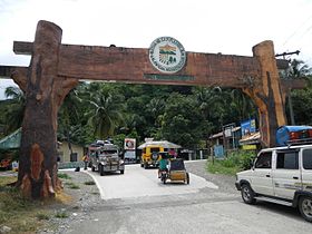
Carranglan
Baley na Pilipinas ed luyag na Nueva Ecija
Page Module:Infobox/styles.css has no content.
| Carranglan | |
|---|---|
| Baley na Filipinas | |
 | |
 Lokasyon na Carranglan | |
 | |
| 15°57′39″N 121°3′47″E | |
| Dalin | Filipinas |
| Barangay | 17 |
| Kaawang | |
| • Katiponan | 705.31 km2 (272.32 sq mi) |
| Elebasyon | 305 m (1,001 ft) |
| Bilang na too (Mayo 1, 2020)[1] | |
| • Katiponan | 42,420 |
| • Densidad | 60/km2 (160/sq mi) |
| Economia | |
| • Clase | unaan ya klase ya baley |
| • Ingresos | ₱254,113,395.97 (2020) |
| • Activos | ₱710,370,912.76 (2020) |
| • Pasivos | ₱326,199,962.09 (2020) |
| • Gastos | ₱196,844,143.07 (2020) |
| Kodigo na postal | 3123 |
| Kodigo na lugar | 44 |
Say Carranglan et unaan ya klase ya baley ed luyag na Nueva Ecija, Filipinas. Unong ed 1 Mayo 2020 census, say populasyon to et 42,420 totoo tan 10,440 abong. Walay kabaleg tan sukat to ya 705.31 sq. km. Say zip code to et 3123.
Saray barangay
dumaen- R.A.Padilla (Baluarte)
- Bantug
- Bunga
- Burgos
- Capintalan
- Joson (Digidig)
- General Luna
- Minuli
- Piut
- Puncan
- Putlan
- Salazar
- San Agustin
- T. L. Padilla Poblacion (Brgy. I)
- F. C. Otic Poblacion (Brgy. II)
- D. L. Maglanoc Poblacion (Brgy.III)
- G. S. Rosario Poblacion (Brgy. IV)
Demograpiko
dumaen| Taon | Pop. | ±% p.a. |
|---|---|---|
| 1903 | 1,468 | — |
| 1918 | 2,716 | +4.19% |
| 1939 | 6,339 | +4.12% |
| 1948 | 6,328 | −0.02% |
| 1960 | 10,100 | +3.97% |
| 1970 | 15,536 | +4.39% |
| 1975 | 16,875 | +1.67% |
| 1980 | 19,891 | +3.34% |
| 1990 | 26,064 | +2.74% |
| 1995 | 29,950 | +2.64% |
| 2000 | 31,720 | +1.24% |
| 2007 | 33,233 | +0.64% |
| 2010 | 37,124 | +4.11% |
| 2015 | 41,131 | +1.97% |
| 2020 | 42,420 | +0.61% |
| Reperensiya: Philippine Statistics Authority[2][3][4] | ||
Saray reperensiya
dumaen- ↑ "2020 Census of Population and Housing (2020 CPH) Population Counts Declared Official by the President". Hulyo 7, 2021. https://psa.gov.ph/content/2020-census-population-and-housing-2020-cph-population-counts-declared-official-president.
- ↑ Census of Population (2015). "Region III (Central Luzon)". Total Population by Province, City, Municipality and Barangay. PSA. Retrieved 29 June 2016.
- ↑ Census of Population and Housing (2010). "Region III (Central Luzon)". Total Population by Province, City, Municipality and Barangay. NSO. Retrieved 29 June 2016.
- ↑ Censuses of Population (1903–2007). "Region III (Central Luzon)". Table 1. Population Enumerated in Various Censuses by Province/Highly Urbanized City: 1903 to 2007. NSO.