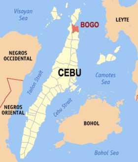
Bogo
Siyudad na Pilipinas ed luyag na Cebu
Page Module:Infobox/styles.css has no content.
| Bogo | |
|---|---|
| Siyudad | |
 Lokasyon na Bogo | |
 | |
| 11°1′12″N 124°0′0″E | |
| Dalin | Filipinas |
| Angipaletnegan | 1850 |
| Barangay | 29 |
| Kaawang | |
| • Katiponan | 103.52 km2 (39.97 sq mi) |
| Elebasyon | 18 m (59 ft) |
| Bilang na too (Mayo 1, 2020)[1] | |
| • Katiponan | 88,867 |
| • Densidad | 860/km2 (2,200/sq mi) |
| Economia | |
| • Clase | kumanem ya klase a siyudad |
| • Ingresos | ₱641,214,613.22 (2020) |
| • Activos | ₱1,563,053,588.73 (2020) |
| • Pasivos | ₱259,173,589.25 (2020) |
| • Gastos | ₱563,240,131.09 (2020) |
| Kodigo na postal | 6010 |
| Kodigo na lugar | 32 |
| Website | www |
Say Bogo et kumanem ya klase a siyudad ed luyag na Cebu, Filipinas. Unong ed 1 Mayo 2020 census, say populasyon to et 88,867 totoo tan 23,260 abong. Walay kabaleg tan sukat to ya 103.52 sq. km. Say zip code to et 6010.
Saray barangay
dumaen- Cogon (Pob.)
- Anonang Norte
- Anonang Sur
- Banban
- Binabag
- Bungtod (Pob.)
- Carbon (Pob.)
- Cayang
- Dakit
- Don Pedro Rodriguez
- Gairan
- Guadalupe
- La Paz
- La Purisima Concepcion (Pob.)
- Libertad
- Lourdes (Pob.)
- Malingin
- Marangog
- Nailon
- Odlot
- Pandan (Pandan Heights)
- Polambato
- Sambag (Pob.)
- San Vicente (Pob.)
- Santo Niño
- Santo Rosario (Pob.)
- Siocon
- Taytayan
- Sudlonon
Demograpiko
dumaen| Taon | Pop. | ±% p.a. |
|---|---|---|
| 1903 | 14,915 | — |
| 1918 | 23,464 | +3.07% |
| 1939 | 27,517 | +0.76% |
| 1948 | 26,132 | −0.57% |
| 1960 | 29,841 | +1.11% |
| 1970 | 38,055 | +2.46% |
| 1975 | 39,144 | +0.57% |
| 1980 | 42,444 | +1.63% |
| 1990 | 51,083 | +1.87% |
| 1995 | 57,509 | +2.24% |
| 2000 | 63,869 | +2.27% |
| 2007 | 69,123 | +1.10% |
| 2010 | 69,911 | +0.41% |
| 2015 | 78,120 | +2.14% |
| 2020 | 88,867 | +2.57% |
| Reperensiya: Philippine Statistics Authority[2][3][4] | ||
Saray reperensiya
dumaen- ↑ "2020 Census of Population and Housing (2020 CPH) Population Counts Declared Official by the President". Hulyo 7, 2021. https://psa.gov.ph/content/2020-census-population-and-housing-2020-cph-population-counts-declared-official-president.
- ↑ Census of Population (2015). "Region VII (Central Visayas)". Total Population by Province, City, Municipality and Barangay. PSA. Retrieved 29 June 2016.
- ↑ Census of Population and Housing (2010). "Region VII (Central Visayas)". Total Population by Province, City, Municipality and Barangay. NSO. Retrieved 29 June 2016.
- ↑ Censuses of Population (1903–2007). "Region VII (Central Visayas)". Table 1. Population Enumerated in Various Censuses by Province/Highly Urbanized City: 1903 to 2007. NSO.