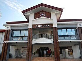
Bacnotan
Baley na Pilipinas ed luyag na La Union
(Redirected from Bacnotan, La Union)
Page Module:Infobox/styles.css has no content.
| Bacnotan | |
|---|---|
| Baley na Filipinas | |
 | |
 Lokasyon na Bacnotan | |
 | |
| 16°43′11″N 120°20′53″E | |
| Dalin | Filipinas |
| Barangay | 47 |
| Kaawang | |
| • Katiponan | 76.60 km2 (29.58 sq mi) |
| Elebasyon | 22 m (72 ft) |
| Bilang na too (Mayo 1, 2020)[1] | |
| • Katiponan | 44,388 |
| • Densidad | 580/km2 (1,500/sq mi) |
| Economia | |
| • Clase | unaan ya klase ya baley |
| • Ingresos | ₱236,536,616.92 (2020) |
| • Activos | ₱1,216,421,917.73 (2020) |
| • Pasivos | ₱112,683,023.41 (2020) |
| • Gastos | ₱201,500,380.40 (2020) |
| Kodigo na postal | 2515 |
| Kodigo na lugar | 72 |
| Website | www |
Say Bacnotan et unaan ya klase ya baley ed luyag na La Union, Filipinas. Unong ed 1 Mayo 2020 census, say populasyon to et 44,388 totoo tan 11,675 abong. Walay kabaleg tan sukat to ya 76.60 sq. km. Say zip code to et 2515.
Saray barangay
dumaen- Agtipal
- Arosip
- Bacqui
- Bacsil
- Bagutot
- Ballogo
- Baroro
- Bitalag
- Bulala
- Burayoc
- Bussaoit
- Cabaroan
- Cabarsican
- Cabugao
- Calautit
- Carcarmay
- Casiaman
- Galongen
- Guinabang
- Legleg
- Lisqueb
- Mabanengbeng 1st
- Mabanengbeng 2nd
- Maragayap
- Nangalisan
- Nagatiran
- Nagsaraboan
- Nagsimbaanan
- Narra
- Ortega
- Paagan
- Pandan
- Pang-pang
- Poblacion
- Quirino
- Raois
- Salincob
- San Martin
- Santa Cruz
- Santa Rita
- Sapilang
- Sayoan
- Sipulo
- Tammocalao
- Ubbog
- Oya-oy
- Zaragosa
Demograpiko
dumaen| Taon | Pop. | ±% p.a. |
|---|---|---|
| 1903 | 8,883 | — |
| 1918 | 11,619 | +1.81% |
| 1939 | 11,678 | +0.02% |
| 1948 | 13,793 | +1.87% |
| 1960 | 15,859 | +1.17% |
| 1970 | 21,031 | +2.86% |
| 1975 | 23,126 | +1.92% |
| 1980 | 24,800 | +1.41% |
| 1990 | 29,568 | +1.77% |
| 1995 | 32,634 | +1.87% |
| 2000 | 35,419 | +1.77% |
| 2007 | 38,743 | +1.24% |
| 2010 | 40,307 | +1.45% |
| 2015 | 42,078 | +0.82% |
| 2020 | 44,388 | +1.06% |
| Reperensiya: Philippine Statistics Authority[2][3][4] | ||
Saray reperensiya
dumaen- ↑ "2020 Census of Population and Housing (2020 CPH) Population Counts Declared Official by the President". Hulyo 7, 2021. https://psa.gov.ph/content/2020-census-population-and-housing-2020-cph-population-counts-declared-official-president.
- ↑ Census of Population (2015). "Region I (Ilocos Region)". Total Population by Province, City, Municipality and Barangay. PSA. Retrieved 29 June 2016.
- ↑ Census of Population and Housing (2010). "Region I (Ilocos Region)". Total Population by Province, City, Municipality and Barangay. NSO. Retrieved 29 June 2016.
- ↑ Censuses of Population (1903–2007). "Region I (Ilocos Region)". Table 1. Population Enumerated in Various Censuses by Province/Highly Urbanized City: 1903 to 2007. NSO.