Arayat
Baley na Pilipinas ed luyag na Pampanga
(Redirected from Arayat, Pampanga)
Page Module:Infobox/styles.css has no content.
| Arayat | |
|---|---|
| Baley na Filipinas | |
 | |
 Lokasyon na Arayat | |
 | |
| 15°8′57″N 120°46′9″E | |
| Dalin | Filipinas |
| Barangay | 30 |
| Kaawang | |
| • Katiponan | 134.48 km2 (51.92 sq mi) |
| Elebasyon | 55 m (180 ft) |
| Bilang na too (Mayo 1, 2020)[1] | |
| • Katiponan | 144,875 |
| • Densidad | 1,100/km2 (2,800/sq mi) |
| Economia | |
| • Clase | unaan ya klase ya baley |
| • Ingresos | ₱507,340,245.63 (2022) |
| • Activos | ₱444,960,081.64 (2022) |
| • Pasivos | ₱49,975,703.52 (2022) |
| • Gastos | ₱441,845,514.12 (2022) |
| Kodigo na postal | 2012 |
| Kodigo na lugar | 45 |
| Website | www |
Say Arayat et unaan ya klase ya baley ed luyag na Pampanga, Filipinas. Unong ed 1 Mayo 2020 census, say populasyon to et 144,875 totoo tan 32,005 abong. Walay kabaleg tan sukat to ya 134.48 sq. km. Say zip code to et 2012.
Saray barangay
dumaen- Arenas
- Baliti
- Batasan
- Buensuceso
- Candating
- Gatiawin
- Guemasan
- La Paz (Turu)
- Lacmit
- Lacquios
- Mangga-Cacutud
- Mapalad
- Palinlang
- Paralaya
- Plazang Luma
- Poblacion
- San Agustin Norte
- San Agustin Sur
- San Antonio
- San Jose Mesulo
- San Juan Bano
- San Mateo
- San Nicolas
- San Roque Bitas
- Cupang (Santa Lucia)
- Matamo (Santa Lucia)
- Santo Niño Tabuan
- Suclayin
- Telapayong
- Kaledian (Camba)
Demograpiko
dumaen| Taon | Pop. | ±% p.a. |
|---|---|---|
| 1903 | 12,904 | — |
| 1918 | 12,302 | −0.32% |
| 1939 | 22,510 | +2.92% |
| 1948 | 22,783 | +0.13% |
| 1960 | 32,976 | +3.13% |
| 1970 | 45,840 | +3.34% |
| 1975 | 52,739 | +2.85% |
| 1980 | 56,742 | +1.47% |
| 1990 | 73,189 | +2.58% |
| 1995 | 85,940 | +3.05% |
| 2000 | 101,792 | +3.70% |
| 2007 | 118,312 | +2.10% |
| 2010 | 121,348 | +0.93% |
| 2015 | 133,492 | +1.83% |
| 2020 | 144,875 | +1.62% |
| Reperensiya: Philippine Statistics Authority[2][3][4] | ||
Imahe
dumaen-
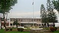 Arayat Town Hall
 -
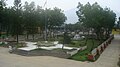 View of the Plaza from the Municipal Hall
 -
 Arayat Municipal Police Station
 -
 Banal na Balon and Our Lady of the Immaculate Concepcion grotto, San Juan Baño
 -
 Convent of Sta. Catalina Church
 -
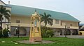
 Heritage Sta. Catalina Church (built in honor of St. Catherine of Alexandria)
 -
 View of San Juan Baño from the grotto of God the Father and the Nativity
 -
 San Juan Baño grotto of God the Father and the Nativity


Saray reperensiya
dumaen- ↑ "2020 Census of Population and Housing (2020 CPH) Population Counts Declared Official by the President". Hulyo 7, 2021. https://psa.gov.ph/content/2020-census-population-and-housing-2020-cph-population-counts-declared-official-president.
- ↑ Census of Population (2015). "Region III (Central Luzon)". Total Population by Province, City, Municipality and Barangay. PSA. Retrieved 29 June 2016.
- ↑ Census of Population and Housing (2010). "Region III (Central Luzon)". Total Population by Province, City, Municipality and Barangay. NSO. Retrieved 29 June 2016.
- ↑ Censuses of Population (1903–2007). "Region III (Central Luzon)". Table 1. Population Enumerated in Various Censuses by Province/Highly Urbanized City: 1903 to 2007. NSO.
Saray gawing ed labas
dumaen- PhilAtlas.com
- Philippine Standard Geographic Code
- Local Governance Performance Management System
- www
.arayat .gov .ph
| This article in the Philippines. You can help Wikipedia by expanding it. |