Nabua
(Redirected from Nabua, Camarines Sur)
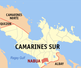
Say Nabua et unaan ya klase ya baley ed luyag na Camarines ed Abalaten, Filipinas. Unong ed 1 Mayo 2020 census, say populasyon to et 86,490 totoo tan 18,313 abong. Walay kabaleg tan sukat to ya 96.20 sq. km. Say zip code to et 4434.
| Nabua | |
|---|---|
| Baley na Filipinas | |
 | |
 Lokasyon na Nabua | |
 | |
| 13°24′30″N 123°22′30″E | |
| Dalin | Filipinas |
| Barangay | 42 |
| Kaawang | |
| • Katiponan | 96.20 km2 (37.14 sq mi) |
| Elebasyon | 16 m (52 ft) |
| Bilang na too (Mayo 1, 2020)[1] | |
| • Katiponan | 86,490 |
| • Densidad | 900/km2 (2,300/sq mi) |
| Economia | |
| • Clase | unaan ya klase ya baley |
| • Ingresos | ₱251,726,549.86 (2020) |
| • Activos | ₱727,388,038.24 (2020) |
| • Pasivos | ₱238,310,473.77 (2020) |
| • Gastos | ₱174,244,620.99 (2020) |
| Kodigo na postal | 4434 |
| Kodigo na lugar | 54 |
Saray barangay dumaen
- Angustia (Angustia Inapatan)
- Antipolo Old
- Antipolo Young
- Aro-aldao
- Bustrac
- Inapatan (Del Rosario Inapat
- Dolorosa (Dolorosa Inapatan)
- Duran (Jesus Duran)
- La Purisima (La Purisima Agu)
- Lourdes Old
- Lourdes Young
- La Opinion
- Paloyon Proper (Sagrada Palo)
- Salvacion Que Gatos
- San Antonio (Poblacion)
- San Antonio Ogbon
- San Esteban (Poblacion)
- San Francisco (Poblacion)
- San Isidro (Poblacion)
- San Isidro Inapatan
- Malawag (San Jose Malawag)
- San Jose (San Jose Pangaraon)
- San Juan (Poblacion)
- San Luis (Poblacion)
- San Miguel (Poblacion)
- San Nicolas (Poblacion)
- San Roque (Poblacion)
- San Roque Madawon
- San Roque Sagumay
- San Vicente Gorong-Gorong
- San Vicente Ogbon
- Santa Barbara (Maliban)
- Santa Cruz
- Santa Elena Baras
- Santa Lucia Baras
- Santiago Old
- Santiago Young
- Santo Domingo
- Tandaay
- Topas Proper
- Topas Sogod
- Paloyon Oriental
Demograpiko dumaen
| Taon | Pop. | ±% p.a. |
|---|---|---|
| 1903 | 18,893 | — |
| 1918 | 19,314 | +0.15% |
| 1939 | 29,433 | +2.03% |
| 1948 | 42,946 | +4.29% |
| 1960 | 66,657 | +3.73% |
| 1970 | 44,417 | −3.97% |
| 1975 | 48,635 | +1.84% |
| 1980 | 53,295 | +1.85% |
| 1990 | 60,885 | +1.34% |
| 1995 | 65,988 | +1.52% |
| 2000 | 70,909 | +1.55% |
| 2007 | 75,422 | +0.85% |
| 2010 | 80,111 | +2.22% |
| 2015 | 83,874 | +0.88% |
| 2020 | 86,490 | +0.61% |
| Reperensiya: Philippine Statistics Authority[2][3][4] | ||
Saray reperensiya dumaen
- ↑ "2020 Census of Population and Housing (2020 CPH) Population Counts Declared Official by the President". Hulyo 7, 2021. https://psa.gov.ph/content/2020-census-population-and-housing-2020-cph-population-counts-declared-official-president.
- ↑ Census of Population (2015). "Region V (Bicol Region)". Total Population by Province, City, Municipality and Barangay. PSA. Retrieved 29 June 2016.
- ↑ Census of Population and Housing (2010). "Region V (Bicol Region)". Total Population by Province, City, Municipality and Barangay. NSO. Retrieved 29 June 2016.
- ↑ Censuses of Population (1903–2007). "Region V (Bicol Region)". Table 1. Population Enumerated in Various Censuses by Province/Highly Urbanized City: 1903 to 2007. NSO.
Saray gawing ed labas dumaen